
How to photograph a sunset, and above all where to stand
To photograph a sunset well, the time is not enough. Here is how to scout the sun's direction, account for the terrain, and set the camera up right.
Photo and video
Suncam
Suncam draws the exact direction of sunset on a map, and works out the hour a ridge puts you in shadow long before the official time in the almanac.
Free for 7 days, then a single €9.99 purchase. No subscription, no account to create, and the data stays on the iPhone.
20 km
the radius of terrain analysed around the point, ridges included
a few seconds
the gap against the US Naval Observatory ephemerides
0 network
everything is computed on the device, except the terrain analysis
01 The starting point
Most sunset apps answer the almanac's question: at what time does the sun pass below the theoretical horizon, the one belonging to a flat sea. That is an exact answer and often a useless one.
In the field, what matters is different. If a ridge stands to the west of your spot, the sun disappears behind it well before the stated time. I have made the drive more than once only to arrive in a valley that had been in shadow for forty minutes, with an official time still promising me light.
Suncam answers both questions, but above all the second one. It draws the exact direction of sunset on a map, and works out the moment the sun really goes, terrain included.
The official sunset time assumes a flat horizon. Almost no interesting place has one.
02 The map
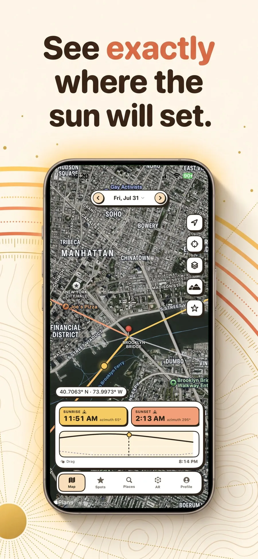
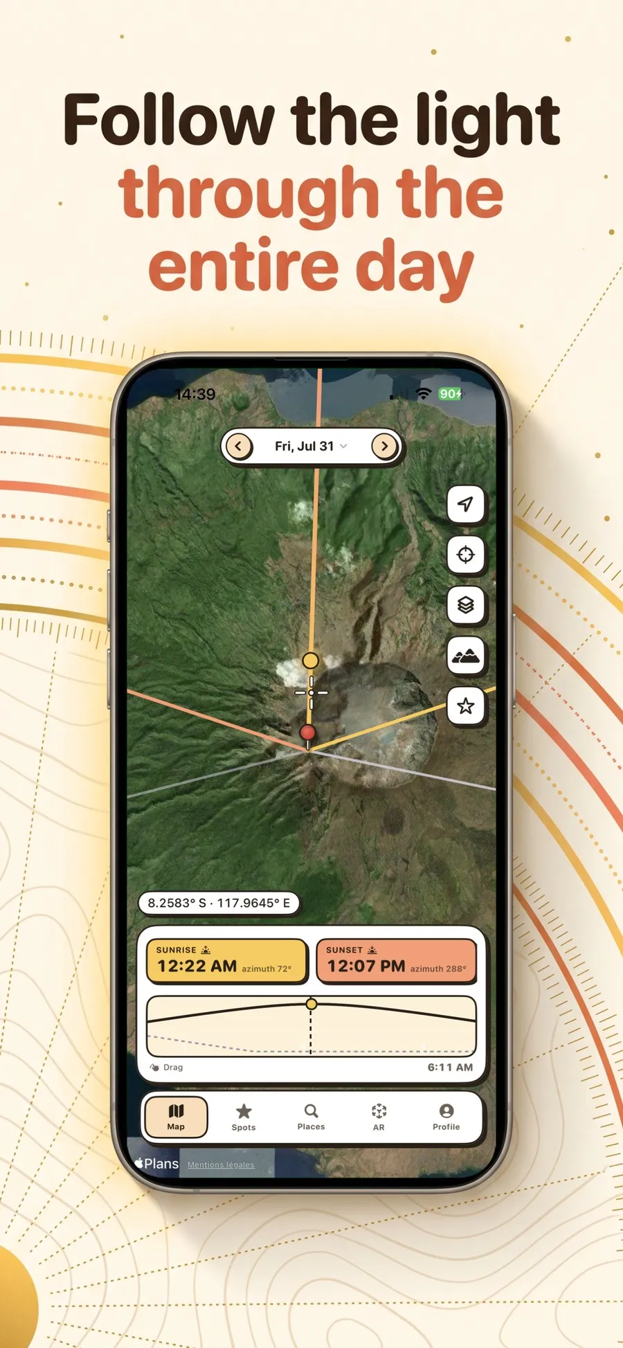
You drop a red pin on the map, in satellite, plan or hybrid view, and the app immediately draws two lines from it. Gold runs towards sunrise, coral towards sunset, each with its azimuth in degrees. Two more discreet grey lines do the same for the moon.
That drawing is what makes planning concrete. Knowing sunset is at 9.47 pm doesn't tell you whether the sun will drop behind the church or beside it; seeing the coral line pass exactly over the steeple does.
The time tiles under the map always show sunrise and sunset, then the golden hours, the blue hours, and depending on your settings the nautical or astronomical dawns and dusks, solar noon and the moon.
03 The timeline
At the bottom of the map, a timeline covers the whole day, coloured by light phase. You drag it with your thumb and the sun turns live on the map: the line pivots, the gradient follows, the numbers recalculate.
It is the most useful gesture in the app, because it turns a table of times into something you grasp at a glance. You see at which point in the afternoon the light will come in from the left, and at which point it will pass behind your subject.
The date picker at the top does the same across the year. Scouting a place in February to come back in June means knowing how far the path will have shifted, and that takes two taps to see.
04 The terrain
This is the feature I wrote the app for. The "Shadow and light" screen analyses the heights all around your point, on an adjustable radius up to 20 kilometres, and turns them into a panorama of the real horizon, east to west.
The sun's path is overlaid on that panorama, with its position at the chosen moment. A strip then shows the slots when you will be in sun, in shadow, or in darkness. And above all, the app gives the real duration of direct light on that point, with the gap against the official day.
On the Lake Annecy example, the official day runs 14 h 49 while direct light on the point runs 12 h 48. Two hours of difference, which explain half of all wasted trips.
The terrain comes from OpenTopoData and the ASTER GDEM model at 30 metres, cached on the device. It is the one feature that needs a network, and only once per place.
Two hours between the official day and the real light. That is where scouting trips go wrong.
05 Augmented reality
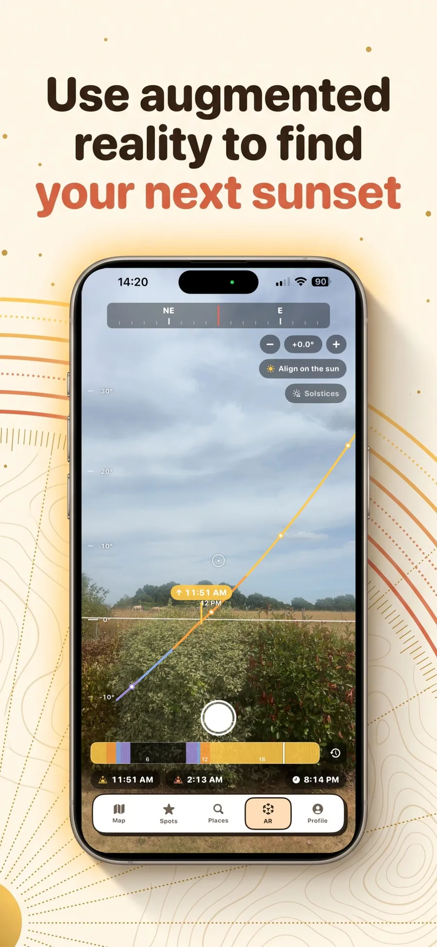
You raise the phone and the sun's path is overlaid on the real landscape, with the day's arc coloured by light phase and the sunrise and sunset markers planted at their exact azimuth.
An elevation ruler and a compass ribbon frame the view. A single tap while aiming at the sun realigns the whole thing, which corrects magnetometer drift, routine near a car or any metal structure.
The solstice paths can be shown too, which gives you at one glance the two extremes between which the light will travel across that spot over the year.
06 The spots
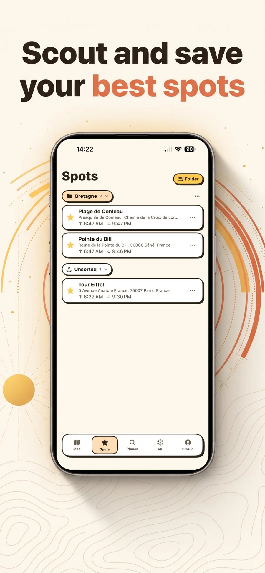
You search for a place, add it to your spots with a tap on the star, and file it into a folder by dragging. Every spot stays visible on the map, at every zoom level.
Each spot shows the day's times in its own time zone. That detail matters as soon as you are planning a trip: the sunset of a spot in Iceland, read from France, doesn't happen on Paris time.
There is also a feature I haven't seen anywhere else: asking on which dates the sun will set along the axis of a street or a valley. The answer comes back as ranges of dates, and when the axis is never reached, the app tells you between which bounds the sun actually sweeps the horizon.
Jean Meeus and NOAA algorithms, compared against the US Naval Observatory ephemerides.
Heights analysed up to 20 km, and the real duration of direct light on the point.
Seven days to try it, then €9.99 once. No account to create.
Except the first terrain analysis of a place, which is then cached on the device.
Suncam doesn’t give you the weather. It tells you where the sun will be, not whether there will be cloud in front of it. Those are two different jobs, and I would rather do the first one properly than both of them badly.
It doesn’t take the photograph for you either, despite the shutter button in the augmented reality view: that one is there to keep a record of the scouting, not to make the image.
Finally, it is light mode only. Dark mode was deliberately set aside, because an app about light is read on pale paper, and the contrast between the gold and coral lines is lost on black.
Plenty of apps of this kind give you times without saying where they come from. That is awkward, because a few minutes of drift is enough to miss a light that only lasts that long.
So sun and moon positions are computed from the algorithms published by Jean Meeus and by NOAA, on the device. The resulting times were then compared against the US Naval Observatory ephemerides, across latitudes from the tropics to the Arctic Circle. The gap is measured in seconds, and anyone can check it from the same sources.
Suncam has no account and I run no server: nothing you save ever reaches me. Only two services receive coordinates in order to work, terrain elevation on one side, Apple’s map on the other. The detail, including the list of permissions the app asks for, is in the Suncam privacy policy.
The seven-day trial, the one-time purchase with no subscription, the limits of the calculations and the legal notice are in the terms of use.
Knowing where the light will be, not only when. You drop a pin on a map and the app draws the exact direction of sunrise and sunset from that point, gives the day's times, and works out whether terrain will put you in shadow before the official hour.
The official time assumes a flat horizon. If a ridge stands to the west of your point, the sun disappears behind it well before. Suncam analyses heights on a radius of up to 20 kilometres and shows the real duration of direct light, with the gap against the official day.
Sun and moon positions are computed on the device from the Jean Meeus and NOAA algorithms. The times were compared against the US Naval Observatory ephemerides, from the tropics to the Arctic Circle, and the gap is measured in seconds.
Yes. You aim at a subject on the map, the axis is computed from your point, and the app answers with ranges of dates, for sunrise as well as sunset. When the axis is never reached, it tells you between which bounds the sun actually sweeps the horizon.
Yes, with one exception. Every position calculation happens on the device. Only the first terrain analysis of a place needs a connection, and the data is then cached on the iPhone.
It is free for seven days, then a single purchase of €9.99. There is no subscription and no account to create.
From OpenTopoData, on the ASTER GDEM elevation model at 30 metres produced by NASA and METI. The mapping comes from Apple Maps.
Download
Suncam is on the App Store.